

Posts tonen met het label polder. Alle posts tonen
Posts tonen met het label polder. Alle posts tonen
29 september 2017
View from the Reidehoeve visitor center
27 september 2017
Johannes Kerkhovenpolder

I'm linking to signs, signs.
26 september 2017
Agriculture

The ground in this coastal region consists of marine clay which is very fertile and used for agriculture, like potatoes and sugar beets.

19 juni 2017
Tunnel mural

I'm linking to Monday Mural.
17 juni 2017
Lappenvoort Polder


23 mei 2014
Onnerpolder

The Onnerpolder is a nature area in the province Groningen, near Haren and Groningen city. Even though industry isn't far away -you can see it clearly in the distance- it's a beautiful place with lots of birds and other wildlife.
28 april 2014
Onnerpolder

A picture from last Saturday while hiking in the Onnerpolder, a wide nature area in the province Groningen.
13 december 2013
Reiderwolderpolder
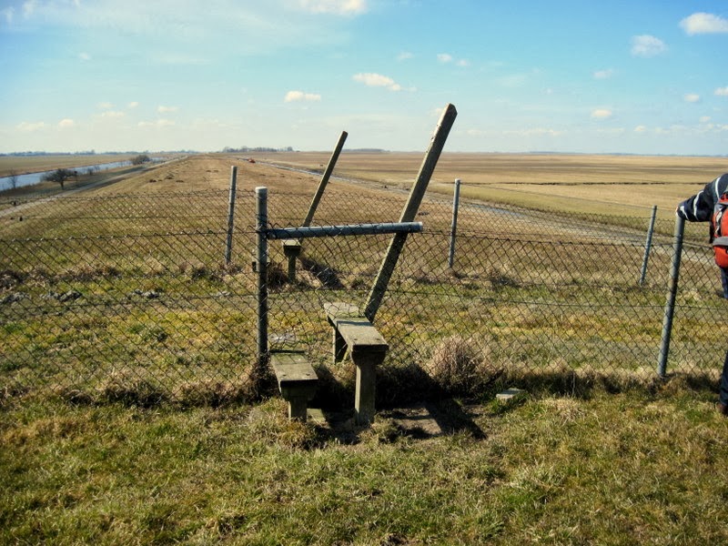
View from the dike in the vast Reiderwolderpolder, in the far north east of the province Groningen. Fences divide the grounds for sheep.

Hikers are welcome, you cross the fence by stepping over it.
Linking to Friday's fences #109
16 mei 2013
Reiderwolderpolder

Nogmaals de weidsheid van de Reiderwolderpolder.
The vast Reiderwolderpolder once more.
14 mei 2013
R is for Reiderwolderpolder

Nederland heeft enkele duizenden (!) polders: door waterkeringen (dijken) omgeven gebieden waarvan de waterstand kunstmatig geregeld kan worden. Een voorbeeld is de Reiderwolderpolder, in het noordoosten van Groningen. Via een 'coupure', ook wel dijkgat genoemd, rij je hier de polder in. In geval van calamiteiten kan deze opening gesloten worden met rijen balken of een deur.
In the Netherlands you can find several thousands (!) of polders: pieces of land enclosed by embankments (dikes) in which the waterlevel is handled through manually operated devices. One of them is the Reiderwolderpolder, in the northeast of the province Groningen. You enter the polder by a 'coupure', an opening in the dike that -in case of a calamity- can be closed by rows of beams or a door.

De Reiderwolderpolder ontstond in de 19e eeuw door drooglegging van een gebied dat in de eeuwen ervoor was overstroomd door de Dollard, die tussen noord Nederland en Duitsland stroomt. De afwatering wordt geregeld door de sluis bij Nieuwe Statenzijl.
The land of the Reiderwolderpolder was reclaimed in the 19th century from an area that had been overflowed during several centuries by the Dollard, a bay between the northern Netherlands and Germany. The drainage is managed by the locks of Nieuwe Statenzijl.
Linking to ABC Wednesday.
8 april 2013
Spring is in the air

Ja, er was geduld voor nodig, maar de lente zit definitief in de lucht. Deze beide fietsers genieten van de zon, en de luwte van de dijk waarvandaan ik deze foto genomen heb. -bij Nieuwe Statenzijl, in het hoge noordoosten van Nederland.
Yes, it took a long time but Spring is defenitely in the air. These cyclists enjoy the sun, and the shelter of the dike on which I stood taking this picture. -near Nieuwe Statenzijl in the very northeast of the Netherlands.
Abonneren op:
Posts (Atom)